news
UN-REDD Rolls out Benefits and Risks Tool (BeRT)
news
20 October 2009: The Food and Agriculture Organization of the UN (FAO) and numerous partners have made available free, high-resolution and ready-to-use satellite data as part of the Global Forest Resources Assessment.
The monitoring system provides data at 13,000 land locations across a global grid, and will improve global and regional information in the FAO’s […]
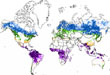 20 October 2009: The Food and Agriculture Organization of the UN (FAO) and numerous partners have made available free, high-resolution and ready-to-use satellite data as part of the Global Forest Resources Assessment.
The monitoring system provides data at 13,000 land locations across a global grid, and will improve global and regional information in the FAO’s assessments of forest change. FAO Director General Jacques Diouf highlighted the potential of the system to assist in monitoring, reporting and verification of a mechanism for reduced emissions from deforestation and forest degradation (REDD), noting that “monitoring will be cheaper, more accurate and transparent for countries that want to participate in REDD.” [Press release] [Global Forest Resources Assessment portal] [UN-REDD]