 24 April 2014: Panama has released a map detailing its forest cover and land use as part of its commitments as a Partner Country of the UN-REDD Programme. The map was formally presented to the public by the National Environment Authority (ANAM) in a 24 April 2014 ceremony held in Panama City, Panama.
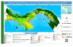
During the map presentation ceremony, Gerardo Gonzalez, ANAM Director of Integrated Watershed Management, stressed that the map will be a cornerstone of the Measurement, Reporting and Verification (MRV) component of REDD+. The map is intended to inform Panamanian decision makers about the current status of forest resources in the country and will serve as the baseline for monitoring deforestation and forest degradation in the future. It will also support the plans for the management of forest resources, territorial zoning and watershed management.
The map includes 32 thematic classes for forest cover and land use, such as forests, forest plantations, agricultural uses (with breakdowns by key crops, such as pineapple, coffee, sugarcane, citrus, plantains and rice), and cultural uses, among others.
The map was prepared over 18 months by a team of 22 people led by ANAM, which processed, interpreted and classifying 290 high-resolution satellite images from 2012. The ANAM-led team included participants from the Food and Agriculture Organization of the UN (FAO), Panama’s REDD+ Project, and the Mesoamerican Biological Corridor of the Panamanian Atlantic (CBMAP). It was funded by the Global Environment Facility (GEF) and the World Bank.
The final version of the map is the product of a verification process in which ANAM convened four workshops to bring together national experts, state institutions, civil society, potential map users and representatives of forest-dependent communities to check that the information contained in the map corresponded with reality in the field. [ANAM Press Release (in Spanish)] [Forest Cover and Land-use Map of Panama]