Air pollution poses a serious risk to human health and increases mortality rates. In 2016, researchers from the Global Burden of Disease Study reported that as many as 5.5 million deaths were associated with air pollution in 2013. The United Nations recognized this issue in the Sustainable Development Goals (SDGs) that were adopted in 2015.
The SDG targets relevant to air quality include:
SDG 11, Target 6, Indicator 2
Goal: Make cities and human settlements inclusive, safe, resilient, and sustainable
Target: By 2030, reduce the adverse per capita environmental impact of cities, including by paying special attention to air quality and municipal and other waste management
Indicator: Annual mean levels of fine particulate matter (e.g. PM2.5 and PM10) in cities (population weighted)
Goal SDG 3, Target 9, Indicator 1
Goal: Ensure healthy lives and promote well-being for all at all ages
Target: By 2030, substantially reduce the number of deaths and illnesses from hazardous chemicals and air, water, and soil pollution and contamination
Indicator: Mortality rate attributed to household and ambient air pollution
Satellite data can help countries assess the impacts of air pollution, especially in regions where ground monitoring is unavailable.
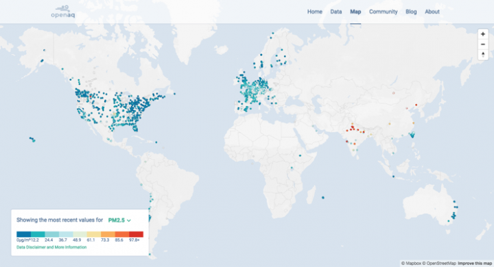
Image 1: PM2.5 ground monitoring stations globally. Source: OpenAQ, http://openaq.org
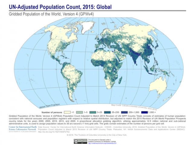
Image 2: Gridded Population Map. Source: NASA SEDAC
Satellite data can help countries assess the impacts of air pollution, especially in regions where ground monitoring is unavailable. Consider image 1, showing the world’s PM2.5 ground monitoring stations, and image 2, a gridded population map. There are large, densely populated areas of the globe where ground monitoring stations do not exist, or provide insufficient coverage.
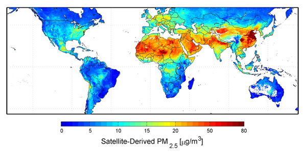
Image 3: Global satellite-derived map of PM2.5 averaged over 2001-2006. Credit: NASA, Dalhousie University, Aaron van Donkelaar
As illustrated by image 3, satellite-derived PM2.5 provides global coverage. The recent US National Aeronautics and Space Administration (NASA) Applied Remote Sensing Training Program (ARSET) webinar, Satellite Derived Annual PM2.5 Data Sets in Support of United Nations Sustainable Development Goals, provided training for participants on how NASA satellite data can and is being used for monitoring the progress of the air quality-relevant SDGs.
PM2.5 is a mass per unit volume measurement (or mass concentration) of particulate matter less than 2.5 μm in aerodynamic diameter at surface level. Even short-term exposure to PM2.5 can be detrimental to human health. It can lead to increased hospital admissions, cardiovascular and respiratory diseases, and mortality rates. Traditionally, PM2.5 is measured using ground monitors, but it can be estimated from satellite measurements, particularly from aerosol optical depth (AOD).
AOD is a unitless quantity, an optical measurement that represents aerosol (or particulate matter) loading in a column of atmosphere from the Earth’s surface to the top of the atmosphere. AOD depends on the shape, size, chemical composition, number concentration of aerosols, and wavelength of the measurement. The webinar series covered the relationship between AOD and PM2.5, as well as methods to estimate near surface PM2.5 using satellite-derived AOD.
Led by the World Health Organization (WHO) and the University of Bath, the Data Integration Model for Air Quality (DIMAQ) combines population data, ground monitors and information on local monitoring networks, simulated aerosols, topography and land use, and satellite-based estimates to generate gridded and country-level estimates of PM2.5, as well as their associated measures of uncertainty. Estimates of PM2.5, such as these, are what will be most applicable to the SDGs.
The last session of the webinar featured an interactive session where participants were able to view the WHO PM2.5 gridded estimates using an open source GIS tool and calculate basic statistics. During the live training, 391 participants from 298 organizations and 61 countries learned how to access PM2.5 estimates, create a detailed map of their country of interest, and create and analyze a user-specified subset (e.g. a specific city or county). One attendee said, “[I] assist in coordination of SDG 11 related events: workshops, review of metadata, development of training toolkits (SDG 11 indicators). The webinar is important in terms of development of training toolkits, alternative methods of data collection.”
All sessions of the training were recorded, and are available for free online at the ARSET website, along with copies of the materials, available in English and Spanish.
NASA’s ARSET empowers the global community through remote sensing training. Since 2009, more than 9,000 people have participated in ARSET trainings, coming from more than 2,600 organizations and 160 countries around the world. These online and in-person trainings focus on applications of satellite observations for disasters, health and air quality, land, and water resources.